Very happy Shirley atop pitch 2 of Mountaineers Route (Jul. 2004).
After hiking past The Perch on our way to and from Warbonnet in late summer of 2003, Shirley & I wanted to come back for the easiest line on the formation. That time turned out to be the 4th Of July Weekend in 2004 and the line of choice was the Mountaineers Route (5.9). I no longer recall why, but we flew to Boise for this one…on a 3-day weekend from Portland this makes little sense unless you’re too lazy to drive 11+ hours each way (which we are not). Oh well. I recall nice, stress free climbing though I did screw up somewhere up high (near the diamond shaped face) and had to penji over back to the line proper. We had some extra hiking up top to reach the summit as we had to navigate around large snowfields. A great outing.
Photos
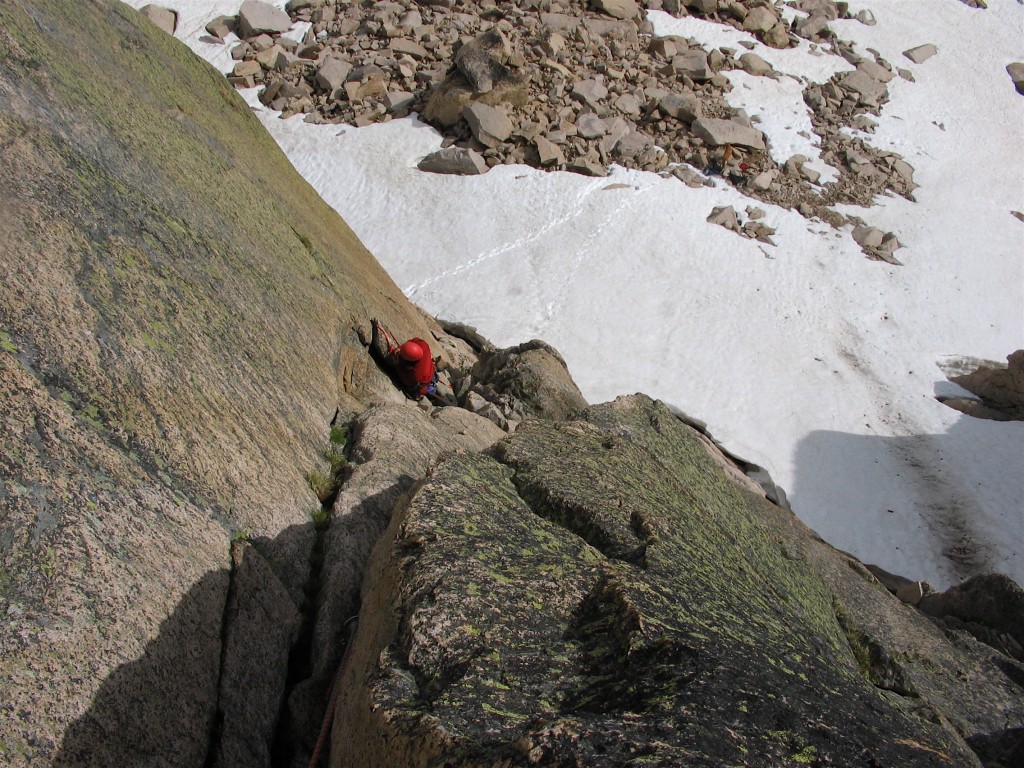
The Redfish Lake Marina.........where climbers and tourons need to coexist in close proximity to each other. This is the usual starting point for the approach to Elephants Perch. Look at that beautiful clear lake with sandy bottom - hard to resist jumping in (July 3, 2004). Shirley hiking in to Elephants Perch (Jul. 2004). Shirley hiking in towards The Perch with Mount Heyburn in background (Jul. 2004). The flowery foothills of Mount Heyburn as seen from the Redfish Creek Trail on the approach to Elephants Perch (July 3, 2004). Shirley on the hike in to the Elephants Perch (Jul. 2004). Saddleback Peak from the approach hike to The Perch, which itself is the second hump from the left (part of Saddleback Peak; Jul. 2004). Shirley crossing the high-running stream on our approach to The Perch (Jul. 2004). Looking up at the Mountaineers Route on Elephants Perch from the hike in. The line follows blocky terrain up to the obvious and large left facing dihedral, passes the roofs on the left and disappears from view on the left side of the diamond shaped face (Jul. 2004). Shirley and some mystery dinner in camp at the base of Elephants Perch (Jul. 2004). The 1200 foot SE face of Elephants Perch as seen from the lowest of the Saddleback Lakes. The Mountaineers Route goes up the far left side of the face (near the Diamond); the Beckey Tree can be seen high on the south face; the class 3 (actually it's low class 5 as there's a short chimney to overcome) descent gully is on the right in the shadow (July 3, 2004). Evening over the lakes at the base of The Perch as seen from our camp (Jul. 2004). Goat Perch (I think) as seen from the base of Mountaineers Route on Elephants Perch on the morning of our climb (Jul. 2004). Shirley at the pitch 1 belay admiring the pitch 2 dihedral (Jul. 2004). Shirley at the pitch 1 belay (I think) on Mountaineers Route (Jul. 2004). Shirley entering the dihedral on pitch 2 of Mounties Route (Jul. 2004).
Shirley almost done with the very fun P2 of Mountaineers Route (July 4, 2004). Shirley coming up the nice splitter crack on P2 of Mountaineers Route (July 4, 2004). Very happy Shirley atop pitch 2 of Mountaineers Route (Jul. 2004). Beginning the lead of P3 of Mountaineers Route. Shirley is belaying me from a tiny stance atop P2 - bolts supplemented by cams. P2 and P3 are probably the most fun portions of this climb (July 4, 2004). Beginning the lead of P3 of Mountaineers Route. Shirley is belaying me from a tiny stance atop P2 - bolts supplemented by cams. P3 begins with a nicely exposed traverse left below prominent roofs about 20 feet above the belay (July 4, 2004). Shirley coming up the class 3 gully near the top of P3 of Mountaineers Route. Gully leads to the bottom tip of the Diamond formation. Note that P4 goes up the right hand side slab in the photo (July 4, 2004). Shirley nearing the finish of pitch 3 of Mountaineers Route (Jul. 2004). Leading the lower half of P4 of Mountaineers Route. Shirley is belaying me from the very base of the Diamond (July 4, 2004).
Looking back down to Saddleback Lakes and our camp from high on Mountaineers Route (Jul. 2004).Leading P4 of Mountaineers Route near the top (July 4, 2004).Shirley nearing the belay on P4 of Mountaineers Route (July 4, 2004).Shirley following P5 of the Mountaineers Route (c. 5.7). I messed up the route finding on the lower half of this pitch and a few pendulums were needed to "correct" our course (July 4, 2004).Looking down from just above the crux of the Mountaineers Route (on P6 - this was the crux according to the topo we had) - a 15 foot finger crack section about 5.8+ in difficulty (July 4, 2004).Looking down from just above the crux of the Mountaineers Route (on P6 - this was the crux according to the topo we had) - a 15 foot finger crack section about 5.8+ in difficulty (July 4, 2004).Shirley topping out on the 6th pitch of the Mountaineers Route (July 4, 2004).Shirley (and her huge pack!) topping out on the Mountaineers Route...really don't recall what the hell we had brough with us?? Was it the bbq grill set? It was July afterall...Mommy on the summit of The Perch after climbing Mountaineers Route (July 2004).Daddy on the summit of Elephants Perch after our climb of Mountaineers Route and much scrambling afterwards (Jul. 2004).Shirley chilling in our camp after the climb of Mountaineers Route (July 2004).Looking NW from the lowest of the Saddleback Lakes. Elephants Perch is on the right (a small section is visible). Our camp can be seen on the left. This is the beautiful clear morning after our climb of Elephants Perch (July 5, 2004).Shirley on the hike out after our climb of Mountaineers Route (July 2004).Shirley waiting for the boat shuttle at Redfish Lake after our climb of Mountaineers Route on The Perch (& picking out thorns and splinters from her hands; July 2004).